SCCWRP exploring expanded use of extrapolation modeling technique for stream condition assessments

SCCWRP and its partners are exploring how to expand use of a modeling technique for extrapolating bioassessment results to unmonitored stream reaches, following the completion of a pilot study that successfully applied the approach to six watersheds in California.
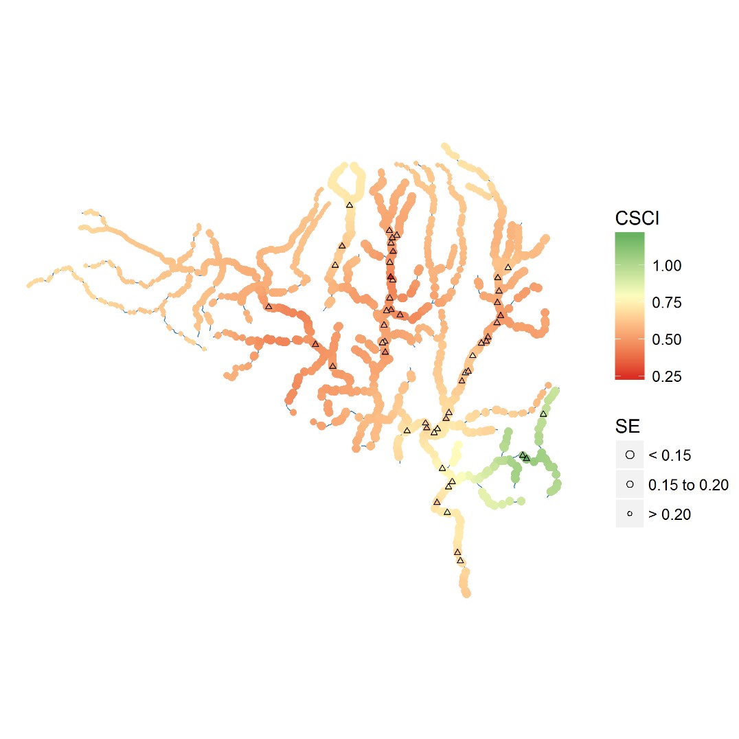
The bioassessment data extrapolation map for the Malibu Creek watershed, above, shows how limited field bioassessment data points, plotted as triangles, are used to extrapolate bioassessment data across all stream reaches within a watershed. The bioassessment scores are calculated using the California Stream Condition Index (CSCI) scoring tool; the size of each colored point indicates the level of confidence in the prediction (SE = standard error).
The extrapolation technique, known as Spatial Statistical Network (SSN) modeling, reveals the geographical extent to which ecological condition scores calculated for stream sampling sites may be extrapolated to unsampled reaches upstream and downstream of the sites, with various levels of confidence.
Bioassessment data points don’t cover all stream reaches within watersheds, as some reaches are difficult to access and stream managers don’t have the resources to conduct field bioassessment work along every stream reach in California.
SCCWRP in April published a report describing the application of the extrapolation technique to six demonstration watersheds in California. The project, completed in partnership with the California Stormwater Quality Association, can help stream managers optimize how they apply stream bioassessment data to inform decision-making and policy development at larger scales, from subcatchments to whole watersheds.
SCCWRP is now seeking to broaden the application of the technique to create extrapolated data maps for every stream reach in coastal Southern California. Researchers also are interested in combining field bioassessment data from multiple sources (i.e., from multiple study designs) to create watershed-scale extrapolation maps.
The extrapolation technique has the potential to provide key pieces of information that will aid in watershed planning efforts. SCCWRP is exploring how the extrapolation maps could be used to establish a technical foundation for classifying high-quality vs. impaired streams. Additionally, the extrapolation maps could be used to pinpoint where additional field sampling would be most helpful in improving understanding of overall watershed health.
Furthermore, the extrapolation technique isn’t limited to bioassessment data; SCCWRP also will explore how it could be applied to fill in missing chemistry and toxicity data points for streams.
More news related to: Bioassessment, Indices of Biotic Integrity