Technical foundation created for ephemeral stream tools
SCCWRP and its partners have completed a pair of studies that establish a technical foundation for building watershed management tools for Southern California streams that run dry for much of the year.
The two studies, published as SCCWRP technical reports in December, provide an important proof-of-concept of the feasibility of building tools that can quantitatively assess the health of ephemeral streams, as well as that can model the hydrologic flow patterns of ephemeral streams.
Although ephemeral streams make up about 60% of all streams in Southern California, existing watershed management tools are designed for application in perennial streams only.
The two studies, which were conducted in the Santa Ana and San Diego regions, represent an important step forward in building a suite of ephemeral stream management tools that complement existing perennial stream tools.
During the ephemeral streams condition assessment study, researchers examined the composition of terrestrial arthropod and bryophyte communities living in dry streambeds. Multiple biological indicators were identified that could potentially be used to quantitatively score the condition of these ephemeral streams.
Based on these findings, SCCWRP and its partners are continuing to work toward developing the quantitative scoring tool for ephemeral stream condition; it is expected to be released in 2020.
Furthermore, the ephemeral streams bioindicator data collected during the study is being used to validate the California Rapid Assessment Method (CRAM) tool for ephemeral streams, which was co-developed by SCCWRP. By validating this screening-level ephemeral streams assessment tool, California’s stream managers will have more confidence in the accuracy of the tool, encouraging more widespread adoption among California’s stream monitoring programs.
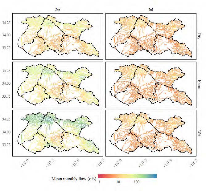
During the ephemeral streams hydrologic mapping project, researchers adapted hydrologic models developed by the U.S. Geological Survey to predict typical monthly flows for ephemeral streams under wet, normal, and dry climatic conditions. Researchers then modeled the impacts that human disturbances have on these flow patterns over time.
The resulting hydrologic maps – available as shapefiles and through an interactive web application – reveal the extent and location of ephemeral streams, as well as capture the dynamic nature of ephemeral stream flows across Southern California over time.
The hydrologic maps have the potential to support a variety of management needs, including prioritizing sites for monitoring, providing evidence for causal assessment studies, forecasting the impacts of land-use changes and climate change, and informing the design of stream bioassessment surveys.
SCCWRP’s work on ephemeral streams has opened the door to partnerships that will expand this science outside of California. Notably, SCCWRP is partnering with the U.S. Environmental Protection Agency and the Arizona Department of Environmental Quality to evaluate the new ephemeral streams tools for Arizona as well.
SCCWRP also is partnering with the EPA to evaluate field-based flow duration assessment tools across the arid Southwest that were originally developed for the Pacific Northwest.
For more information, contact Dr. Raphael Mazor
More news related to: Bioassessment, Indices of Biotic Integrity, Top News