Study provides statewide picture of when, where HABs are occurring in lakes, reservoirs
SCCWRP and its partners have completed a year-long study that used satellite imaging data to build a comprehensive portrait of when and where ecologically disruptive harmful algal blooms (HABs) have been occurring in California’s large lakes and reservoirs over the past five years.
The proof-of-concept study, completed in June for the years 2017 to 2021, illustrates how California can track HABs status and trends at the frequency and scale needed to effectively intervene to manage this growing environmental problem in lakes and reservoirs. California’s HABs management efforts to date have been limited by patchy, sporadic HABs field sampling data that get voluntarily submitted to the State Water Resources Control Board.
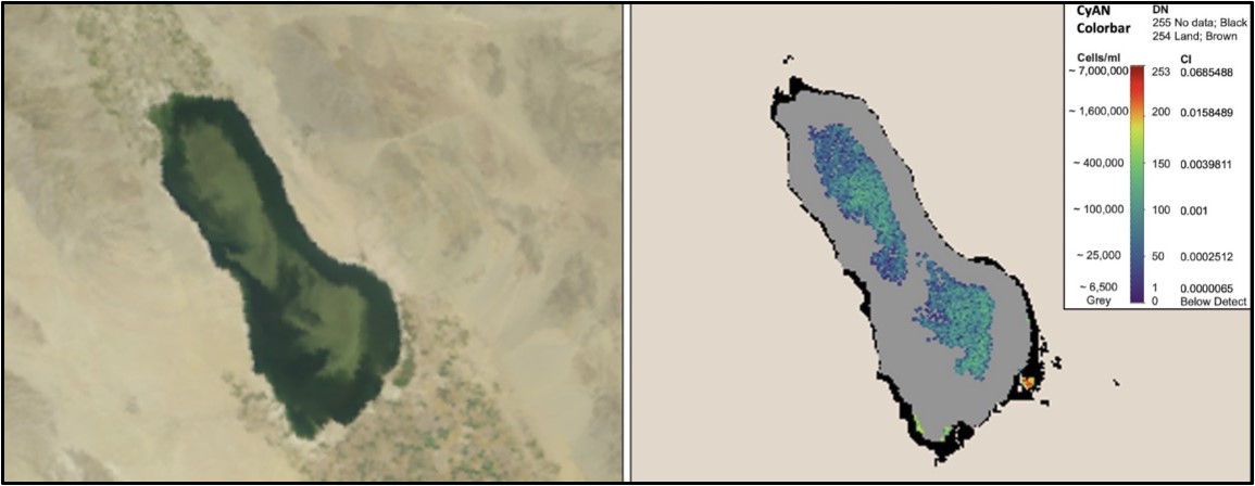
Satellite remote sensing provides a viable, cost-effective way to generate a continuous stream of real-time HABs monitoring data. With remote sensing, high-resolution satellite imagery of large lakes and reservoirs is captured multiple times a week; then, the federal Cyanobacteria Assessment Network (CyAN) applies an algorithm to the imagery to identify the presence and relative concentration of cyanobacteria in surface waters.
Using satellite imagery to detect and assess cyanobacteria blooms has been extensively validated by the CyAN group for use across the U.S., and shown to be a robust way to monitor HABs in large lakes and reservoirs across expansive geographic areas.
The five-year HABs status and trends report is the next evolution in an ongoing effort by California to build HABs monitoring capacity for lakes and reservoirs using satellite imaging data. In 2015, the San Francisco Estuary Institute developed a statewide satellite HABs data tracker that enables managers to track emerging HABs events in individual lakes and reservoirs.
The five-year statewide analysis helps put water body-specific information into regional context, enabling managers to understand when and where HABs threats are greatest, engage in long-term planning and prioritization, and consider developing State and regional policies and programs to minimize adverse environmental effects, including taking more aggressive action to reduce nutrient loading.
Reports of HABs have been increasing in frequency every year since the State Water Board began tracking these cyanobacterial blooms via its voluntary reporting system. In a statewide freshwater HABs monitoring strategy published in 2021, the State Water Board highlighted the need to develop capacity to track bloom frequency and magnitude over time.
Cyanobacterial blooms, which are key indicators of eutrophication, can contaminate aquatic systems with toxins that are harmful to humans, domestic pets and wildlife exposed to the contaminated water.
During the SCCWRP-led pilot study, SCCWRP and its partners successfully identified and applied metrics validated by the federal CyAN group to estimate the status and trends of HABs in 88 large lakes and reservoirs; these water bodies collectively make up about 65% of the surface area of all of California’s large lakes and reservoirs.
Remote sensing does not appear to be effective for monitoring the nearshore regions of large lakes and reservoirs, or when there is cloud cover. Meanwhile, blooms in small lakes and reservoirs would need to be captured using other types of remote sensing imagery than was used in the SCCWRP study.
Researchers presented the findings from the five-year study during a webinar for lake and reservoir managers in July. The research team has now shifted its focus to comparing the remote sensing data to land use and climate data, primarily collected in California’s Central Valley, to identify how these factors may be related to increased HABs.
For more information, contact Dr. Jayme Smith.
More news related to: Eutrophication, Harmful Algal Blooms, Regional Monitoring, Top News