Pilot study shows potential of UAS for remote environmental monitoring applications
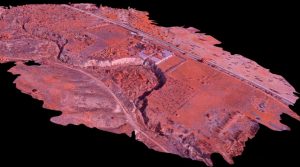
SCCWRP and its partners have demonstrated in a pilot study that traditional and multispectral cameras mounted to an unmanned aerial system (UAS) can be used to produce high-resolution, 3D mapping of waterways susceptible to hydromodification.
The year-long project, which involved flying remote-controlled aircraft over stream channels in south Orange County, provides preliminary evidence that UAS aircraft can be adapted for environmental monitoring applications.
SCCWRP showed that the high-resolution aerial data obtained from the UAS can be used to develop runoff models, track changes to terrain over time, and zero in on a precise location retroactively to take more detailed measurements.
Data obtained from a visible spectrum camera and a multispectral infrared camera showed the most promise, while experimental data from a LiDAR (Light Detection and Ranging) laser profiling system was not initially useful.
SCCWRP is partnering with the San Francisco Estuary Institute to explore how UAS could be used to map harmful algal bloom events, estuaries and wetlands, debris and pollution plumes, and other areas.
This spring, SCCWRP and SFEI are planning to invest in a shared UAS. SCCWRP staff have undergone training to pilot the aircraft and will receive certification from the Federal Aviation Administration.
More news related to: Ecohydrology, Eutrophication, Harmful Algal Blooms